Gulf Of Guinea
A crowded coast between rainforest and sea
Nations 22

The Geography
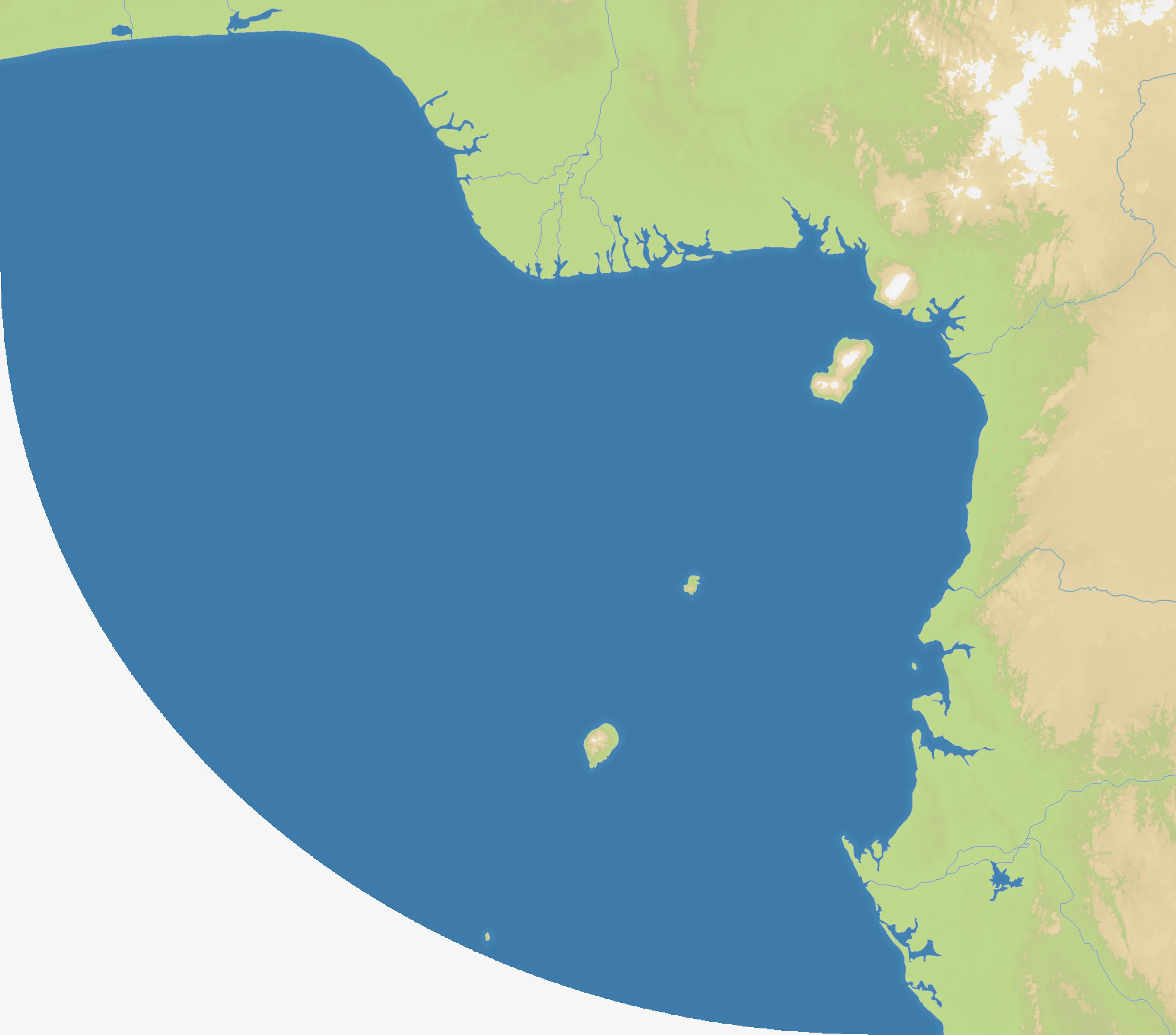
The Gulf of Guinea map follows the West and Central African Atlantic coast from Togo and Benin through Nigeria and Cameroon to Equatorial Guinea and Gabon. The shoreline bends around the gulf while the playable interior reaches inland across the Niger Delta, the Cross River region, the Cameroon highlands, and the forested basins farther south.
The coast is a chain of contrasting spaces: dense river deltas around Lagos, Warri, and Port Harcourt; uplands behind Bafoussam and Bamenda; volcanic islands around Malabo and São Tomé; and the broad, humid Gabonese interior. The map’s many named settlements make it feel less like a single front and more like a web of local theatres connected by the Atlantic coast.
The History
The Bight of Benin — A Coast of Commerce
For centuries, coastal societies around the Bight of Benin connected inland trade networks to Atlantic shipping. Ports and river mouths linked places that are now separated by national borders, turning the coast into a corridor for goods, people, and ideas.
The Colonial Partition
European colonial rule imposed new borders across the region, dividing older political and cultural networks between British, French, German, Portuguese, and Spanish spheres. The modern states represented on this map are therefore layered over a much older geography of rivers, kingdoms, and coastal cities.
Independence and the Oil Delta
After independence, the Gulf of Guinea became one of Africa’s major petroleum-producing regions. Oil wealth, port growth, and rapid urbanisation transformed the Niger Delta and the coastal cities, while also making access to waterways and resources a source of persistent competition.
The Battlefield
Terrain Overview
The gulf is a coastal map with several distinct approaches inland. River deltas and wet lowlands around southern Nigeria create dense, tangled fronts; the Cameroon highlands offer a more defensible elevated route; and the Gabonese side opens into a longer forested arc. The islands around Equatorial Guinea and São Tomé provide offshore positions that can be valuable but difficult to reinforce.
Best Spawns
- Lagos / Porto-Novo — western gateway with immediate coastal access and several routes into the Nigerian heartland
- Douala / Malabo — central maritime position linking the Cameroon coast to the islands and the gulf’s main crossings
- Libreville / Port-Gentil — southern foothold with room to develop along the Gabonese coast before pushing north
Avoid
- Deep Niger Delta — many nearby fronts and waterways can turn an early expansion into a costly tangle
- Isolated island positions — defensible at first, but vulnerable to naval blockades and slow reinforcement
Strategic Insights
Control of the coast is not the same as control of the map. A strong maritime position can connect distant fronts, but the decisive battles often happen where deltas narrow into inland corridors. Secure a reliable route between your coastal core and the highlands before overextending along the shoreline, and treat the islands as staging points rather than automatic safe havens.
Fun Facts
- The map’s named settlements stretch from Lomé and Lagos in the west to Libreville and Port-Gentil in the south.
- São Tomé, Príncipe, and Annobón bring three island theatres into a map otherwise shaped by mainland rivers and forests.
- The Niger Delta, Cameroon coast, and Gabonese interior each produce a noticeably different kind of front.