Crimea
A peninsula between steppe and sea
Nations 9

The Geography
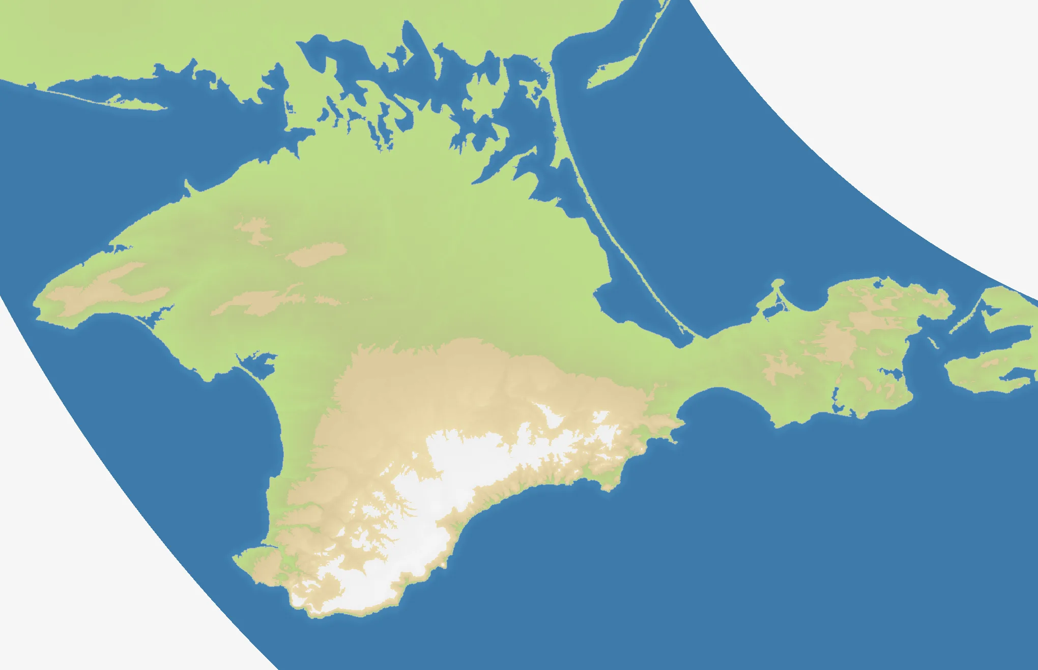
Crimea is a Black Sea peninsula shaped by two very different landscapes. The north is mostly open steppe, joined to mainland Ukraine across the narrow Perekop isthmus and the shallow Syvash lagoons. The south rises into the Crimean Mountains, whose ridges run along the coast before falling toward the Black Sea. At the eastern tip, the Kerch Peninsula faces the Taman Peninsula across the Kerch Strait.
The OpenFront map measures 2040×1316. Its coastline is not decoration: the Black Sea, Sea of Azov, and Kerch Strait turn Crimea into a position with several approaches and no single safe rear. The northern plains favour movement and expansion, while the southern mountains and coastal corridors create natural bottlenecks.
Crimea’s geography has also made it a meeting point of routes from the Pontic steppe, the Black Sea, and the eastern Mediterranean. On the battlefield, that means the peninsula is both a defensible core and a bridge that can expose an empire to pressure from several directions.
The History
Antiquity — Greek colonies and Chersonesus
Greek settlements appeared along the Crimean coast from the 7th century BCE. Chersonesus, near present-day Sevastopol, became an important city and trading centre, linking the Black Sea hinterland with the wider Greek and Roman worlds.
1441–1783 — The Crimean Khanate
The Crimean Khanate emerged in the 15th century as a successor state of the Golden Horde. Its political centre was at Bakhchysarai, and its influence extended across the peninsula and parts of the surrounding steppe. The khanate’s position made Crimea a major frontier between Ottoman, Polish-Lithuanian, and Muscovite spheres.
1783 — Annexation by the Russian Empire
The Russian Empire annexed Crimea in 1783, after the Russo-Turkish wars had weakened Ottoman influence in the region. Sevastopol was founded soon afterward as a naval base, reinforcing the peninsula’s strategic role in the Black Sea.
1944 and 1954 — Deportation and administrative transfer
In 1944, the Soviet authorities deported the Crimean Tatar population from Crimea; the deportation is widely recognized as a grave injustice, and the community’s return began later in the Soviet period. In 1954, Crimea was transferred from the Russian SFSR to the Ukrainian SSR within the Soviet Union.
2014–present — Disputed status
Ukraine has been internationally recognized as sovereign over Crimea. Russia has exercised de facto control since 2014 and claims to have annexed the peninsula, a claim rejected by Ukraine and not recognized by most states. The dispute remains connected to Russia’s wider war against Ukraine.
The Battlefield
Terrain Overview
Crimea is a peninsula map with a broad northern gate, a mountainous southern rim, and a strategically important eastern hinge around Kerch. Interior positions around Simferopol can reach several fronts, but they are also exposed to converging attacks. Coastal cities offer defensive edges and naval options, while the open north rewards whoever establishes a foothold first.
Best Spawns
- Simferopol — central reach toward the northern steppe, southern mountains, and eastern Crimea
- Sevastopol — a strong southwestern anchor with coastal protection and access to the mountain corridor
- Kerch — control of the eastern approach and the route between the Black Sea and Sea of Azov
Avoid
- The far northern approaches — open ground and narrow connections can make an early position easy to surround
- The southern coastal strip — mountains and sea limit lateral movement, so a lost corridor can split the peninsula
- An isolated Kerch advance — the eastern tip is valuable, but difficult to reinforce if the central routes are contested
Strategic Insights
Secure the northern gate before committing deep into the peninsula. The mountains can protect a southern flank, but they also make recovery slow when an opponent captures a pass or coastal corridor. Crimea rewards a layered plan: grow through the open north, hold the central crossroads, and use naval pressure to keep the coasts from becoming a second front.
Fun Facts
- The Crimean Tatar name for Crimea is Qırım.
- The Crimean Mountains occupy the peninsula’s southern edge, while the northern half opens onto the Pontic steppe.
- Bakhchysarai, the historic capital of the Crimean Khanate, lies in a valley in the southwestern interior.