Two Lakes
Twin basins split a nearly landlocked war
Nations 5
The Geography
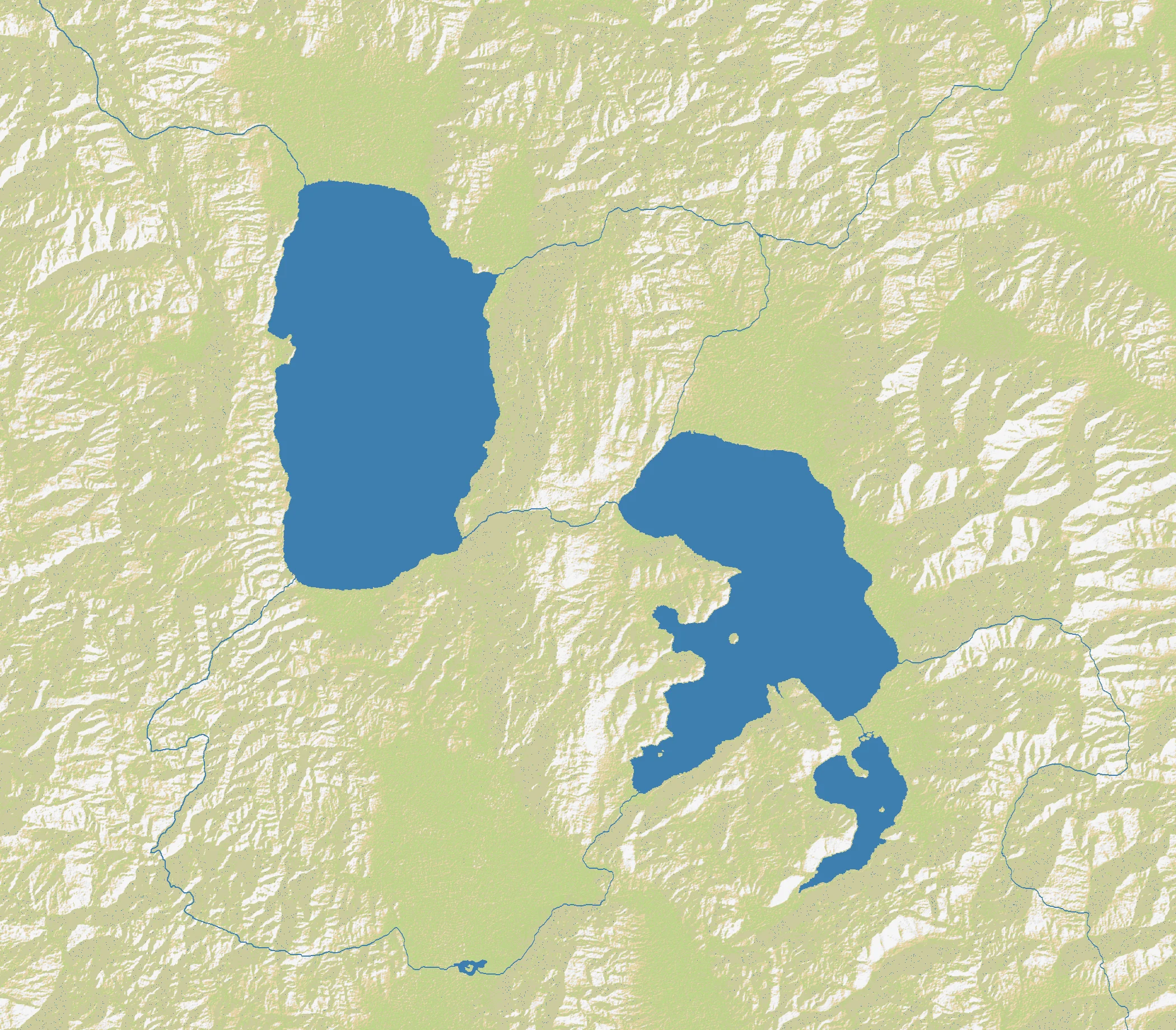
Two Lakes is a regional map built around a simple but effective idea: two major inland water bodies dividing an otherwise land-heavy landscape. The exact inspiration can be read a few ways — the paired inland seas evoke places like Lakes Victoria and Tanganyika in East Africa or certain Great Lakes-style basins — but the gameplay identity is clear regardless. These are not oceans; they are interruptions inside a dominantly terrestrial battlefield.
That matters because the stats are so extreme. At 2100×1840 and 89% land, Two Lakes is one of the most land-dense large regional maps in the atlas. Only 5 nations share that space, which means each player begins with enormous room compared with most maps of this size. Expansion is fast, front lines are broad, and there are very few places to hide. The lakes shape movement, but they do not prevent war from spilling everywhere.
Instead of serving as impassable borders, the lake basins create directional pressure. Players have to choose whether to expand around one shoreline, bridge between the two basins, or treat the water as a rear-area shield while pushing overland elsewhere. Because there are so few nations, those decisions echo for a long time.
The History
Ancient Era — Lakes as Civilizational Anchors
Across the world, major inland lakes have supported trade, farming, fishing, and political centers. Whether in East Africa, North America, or Eurasia, lake basins often become natural gathering points for population because they offer water, transport, and fertile adjoining lands.
19th Century — Interior Trade Networks Expand
In many lake regions, the nineteenth century brought steamships, missionary routes, imperial expeditions, and new commercial corridors. Lakes that once separated communities increasingly linked them — a useful reminder that inland water often connects as much as it divides.
20th Century — Borders Hardening Around Shared Waters
Modern states frequently inherited lakefront boundaries drawn by colonial or diplomatic negotiation. That created a recurring pattern: huge bodies of freshwater bordered by multiple jurisdictions, with ports and crossings becoming outsized strategic assets.
The Battlefield
Terrain Overview
Two Lakes is about land tempo first, water geometry second. The two basins interrupt the center of the map and create arcs of shoreline, but the overwhelming 89% land means armies can still move around them in force. A player who controls the corridor between the lakes often gains the best operational flexibility, while players confined to a single outer edge may find themselves fighting a long, bending front.
Because there are only five nations, the early game is unusually spacious. That can be deceptive. Wide openings lead players to sprawl, and on a map this land-rich, sprawl is dangerous if it creates long thin borders. The lakes offer just enough structure to create anchor points; smart players use them to shorten fronts and protect one side of their empire.
Best Spawns
- Central isthmus between the lakes — best access to both basins and the easiest way to pivot between fronts.
- Broad northern shore — large land reserve with water helping protect one flank.
- Southern outer rim — room to build and a clearer defensive line than most starts get.
Avoid
- Narrow corner pockets beside a lake — they look safe, but they often become dead ends with poor breakout routes.
- Overextended dual-shore starts — tempting early reach, but too hard to defend once enemies mobilize.
Strategic Insights
The biggest trap on Two Lakes is assuming that high land percentage means mindless expansion. It actually means the opposite: because everybody can grow fast, the first player to define a clean, defendable shape gains a lasting advantage. Water is not dominant here, but it is priceless when it helps cut your defensive burden in half.
Winning usually comes from centrality and discipline. Expand hard, but do not grow a frontier you cannot reinforce. If you can own the land bridge between the two basins — or deny it to everyone else — you control the map’s real center of gravity.
Fun Facts
- Lake Victoria is the world’s largest tropical lake, while Lake Tanganyika is among the world’s deepest and oldest freshwater lakes — a pairing that fits the map’s twin-basin feel.
- The Great Lakes contain about one-fifth of the world’s surface fresh water, showing how powerful inland seas can be even without ocean access.
- An 89% land map with only 5 nations creates some of the largest average starting land potential in the atlas.