Pangaea
Before the oceans divided us
Nations 29


The Terrain
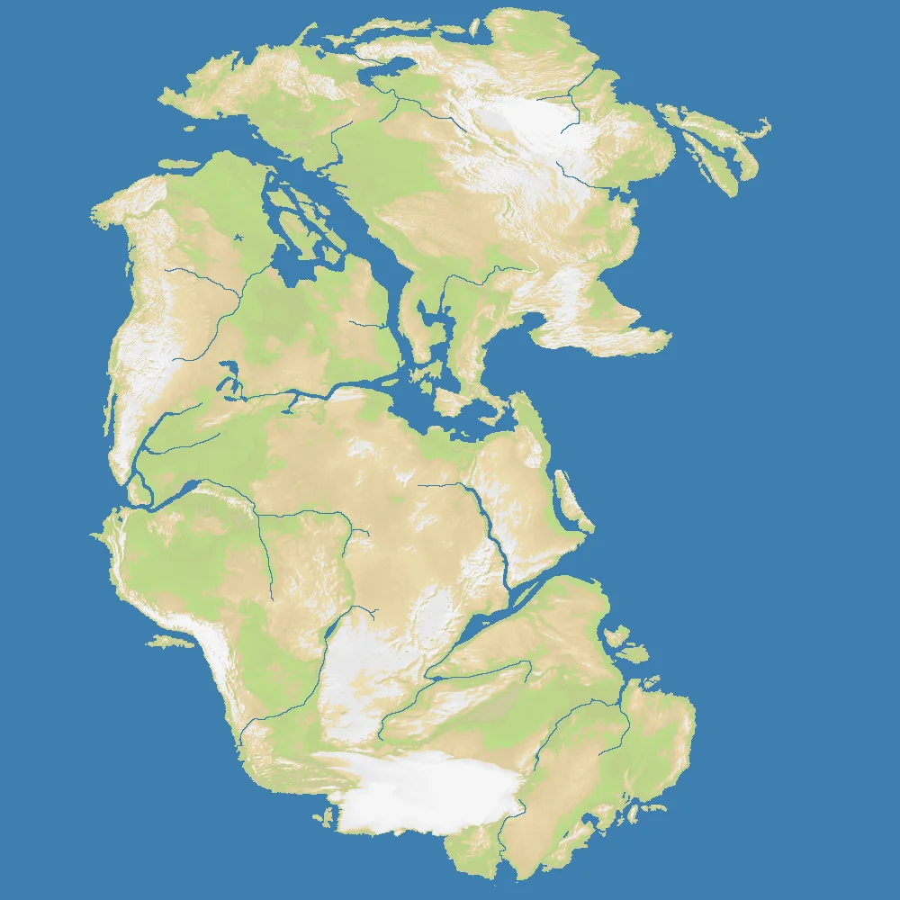
Pangaea (1000×1000) depicts Earth as it appeared roughly 300 million years ago — a single supercontinent surrounded by Panthalassa, the global ocean that covered the rest of the planet. The map renders the characteristic horseshoe shape of the ancient landmass: the northern Laurasia section (future North America, Europe, Asia) connected to southern Gondwana (future South America, Africa, Antarctica, India, Australia) via a narrow central land bridge.
At 42% land, the map is almost exactly half-and-half between the supercontinent and its surrounding ocean. The lack of internal water means this is a purely land-based theatre — no inland seas divide the territory, no island chains offer naval flanking options. Pangaea is a close-quarters land combat map.
The Science
Pangaea existed from approximately 335 million years ago until about 175 million years ago, when rifting began to pull the supercontinent apart. The process of continental drift — driven by convection currents in Earth’s mantle — moved continents at the pace of fingernail growth, a few centimeters per year. Over geological time, this broke Pangaea first into Laurasia and Gondwana, then into the seven continents we know today.
The evidence for Pangaea is written in the rocks: identical fossil species on separated continents, matching geological formations across the Atlantic, and the precise jigsaw fit of continental coastlines. Alfred Wegener proposed the theory in 1912 and was dismissed for decades before plate tectonics vindicated him in the 1960s.
The Battlefield
Terrain Overview
Pangaea is uniquely pure: it’s a land-only conflict on a compact 1000×1000 map. With 29 nations and 42% land coverage, the density is high — every player is close to multiple neighbors from the start. There are no naval escape routes, no island safe zones, no ocean buffers. The entire game is decided on land.
Best Spawns
- Central Pangaea (future Africa / South American junction) — the historical heart of the supercontinent; maximum neighbor access, multiple expansion vectors
- Laurasian northern rim — future North America and European positions; can build along the northern edge before pivoting south
- Southern Gondwana tip — isolated enough for early consolidation; the future Antarctic position is your rearguard
Avoid
- Narrow peninsula positions (Tethys Sea edge) — the Tethys was a shallow sea cutting into the eastern supercontinent; positions near that coastline can get hemmed in quickly
- Tight coastal corners — with no naval option, a coastal spawn that gets landlocked is very hard to recover from
Strategic Insights
Without water, the entire strategic vocabulary shifts. There’s no naval power, no island-hopping, no coastal raiding. Every conflict is a land frontier. The compact size (1000×1000) means games reach decisive moments quickly. Chokepoints emerge from terrain features rather than water barriers — ridge lines, elevated plateaus, the narrow central junction between Laurasia and Gondwana.
Fun Facts
- Pangaea existed for over 100 million years — longer than the age of the dinosaurs
- The Atlantic Ocean opened up roughly 175 million years ago and is still widening today at about 2.5 cm per year
- Pangaea’s name comes from Greek: “pan” (all) + “gaia” (Earth) — literally “all land”