New York City
Harbor islands, bridges, and brutal density
Nations 20


The Geography
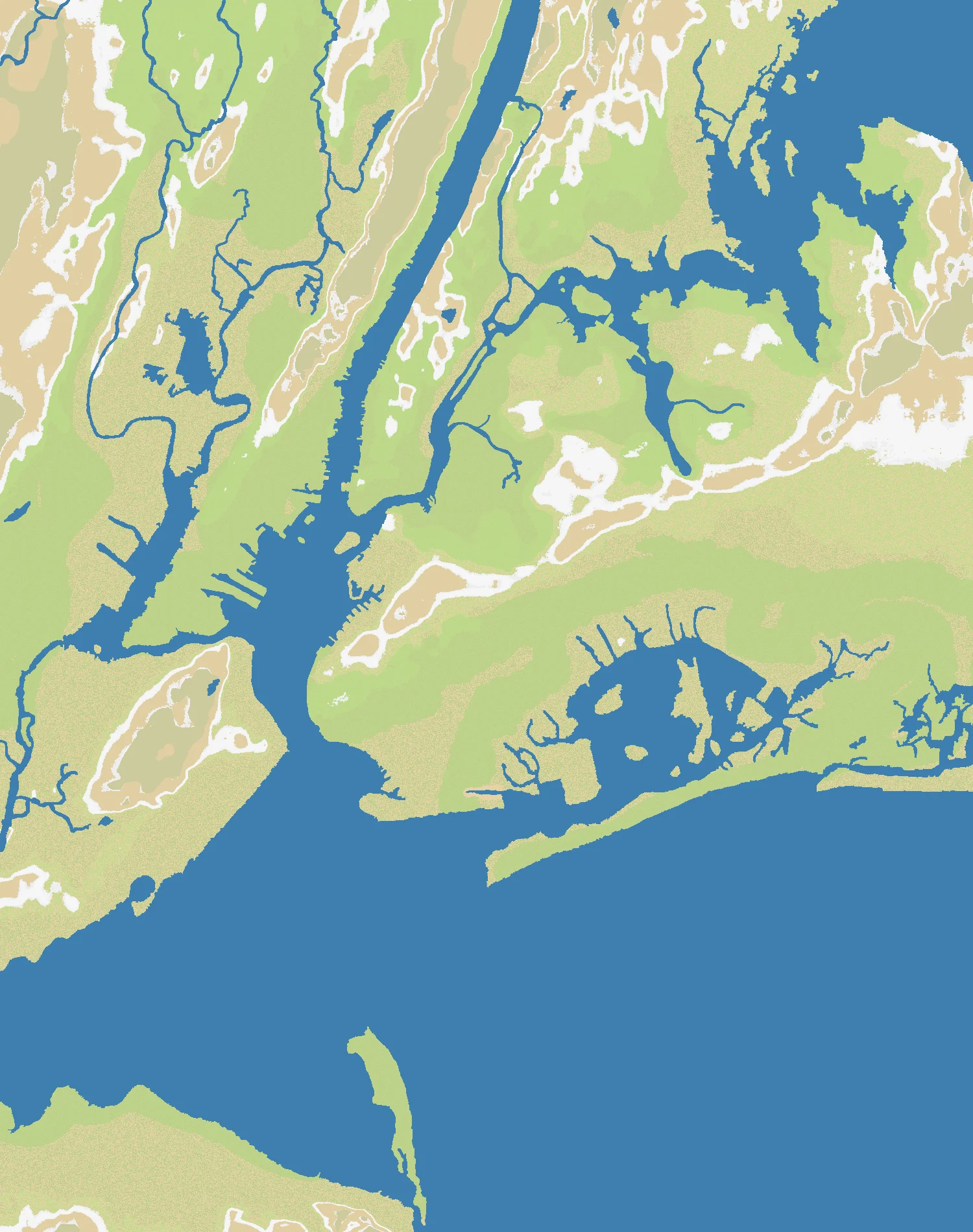
New York City sits where the Hudson River meets the Atlantic, and that geography is exactly why the city exists. Manhattan is a narrow island squeezed between the Hudson, East, and Harlem Rivers. Around it sit the other boroughs — Brooklyn and Queens on the western tip of Long Island, the Bronx on the mainland, and Staten Island guarding the harbor approaches. Add nearby New Jersey waterfront cities, Upper and Lower New York Bay, and the long land bridge of Long Island, and you get one of the most crowded estuarine landscapes on Earth.
On this OpenFront map, that density becomes the main event. The portrait-oriented 1500×1900 canvas gives the region a strong north-south feel, with the Hudson corridor, Manhattan spine, and Long Island extension all pulling armies into narrow lanes. At 58% land, New York City is balanced enough to reward naval play without turning into a pure island match. Water breaks the battlefield into borough-sized theaters, but not so completely that land power becomes irrelevant.
The result is a map where every crossing matters. Rivers, harbor channels, and coastal peninsulas create constant pressure points: Brooklyn vs. Manhattan, New Jersey vs. Staten Island, the Bronx vs. upper Manhattan, and Long Island as both refuge and trap. Few regional maps feel this urban so quickly.
The History
1624 — New Amsterdam Founded
The Dutch established New Netherland at the southern tip of Manhattan, creating the port settlement of New Amsterdam. From the beginning, the city’s power came from maritime geography: a deep natural harbor, river access inland, and a coastline suited to trade.
1776 — The New York Campaign
During the American Revolution, New York became the main military prize of the war’s early phase. Battles on Long Island, at Harlem Heights, and across the harbor approaches showed how whoever held the heights, crossings, and ports could dominate the region.
1942 — Arsenal of the Atlantic
During World War II, New York Harbor became one of the busiest military shipping hubs in the world. Troops, supplies, and war materiel moved through its docks in enormous volumes, reinforcing the city’s longstanding identity as a logistics capital as much as a financial one.
1950s — Civil Defense Metropolis
Cold War planning treated New York as both essential and vulnerable: the symbolic center of American finance, media, and population. Fallout shelters, evacuation plans, and civil defense drills reflected a simple truth — dense coastal cities concentrate both power and risk.
The Battlefield
Terrain Overview
New York City’s terrain is all about constrained movement. Manhattan is long, thin, and exposed at both ends; it looks powerful, but it is easy to isolate if bridges and shoreline access are lost. Brooklyn and Queens offer more room to expand, while New Jersey’s mainland positions can grow fast if they secure crossings before island powers consolidate.
Long Island is the map’s great strategic paradox. It offers space and lateral expansion, but its shape can lure players into overcommitting eastward while the real struggle for the harbor happens farther west. Control of the Hudson approaches and the narrows around Staten Island is often more decisive than simply owning the most raw territory.
Best Spawns
- Brooklyn-Queens waterfront — dense land, multiple bridge routes, and quick access to both Manhattan and Long Island.
- New Jersey shore opposite Manhattan — strong mainland growth with immediate pressure on key river crossings.
- Upper Manhattan-Bronx corridor — central position that can pivot west to the Hudson or east into the boroughs.
Avoid
- Far eastern Long Island — lots of room at first, but too distant from the harbor fight that decides the map.
- Lower Manhattan tip — iconic, but dangerously exposed to naval encirclement and bridge chokeholds.
Strategic Insights
This map punishes players who think in straight lines. The winner is usually the one who treats water as a weapon: block crossings, threaten coastlines, and force opponents to defend on both sides of a river at once. Manhattan is valuable because it is central, not because it is safe.
In larger lobbies, early tempo matters more than raw economy. Grab one secure expansion route, then contest the harbor before someone else turns the bays into a moat. If a rival controls both a mainland base and a strong naval position, they can squeeze every island player on the board.
Fun Facts
- New York Harbor is one of the world’s great natural harbors, with channels deep enough to support the rise of a global port city.
- Long Island is about 190 km long — far larger than most players intuit when they think of “New York City.”
- The New York metropolitan area has a GDP comparable to that of a major country, which fits a map built around concentrated power and competition.