Giant World Map
The whole planet becomes one war
Nations 97


The Geography
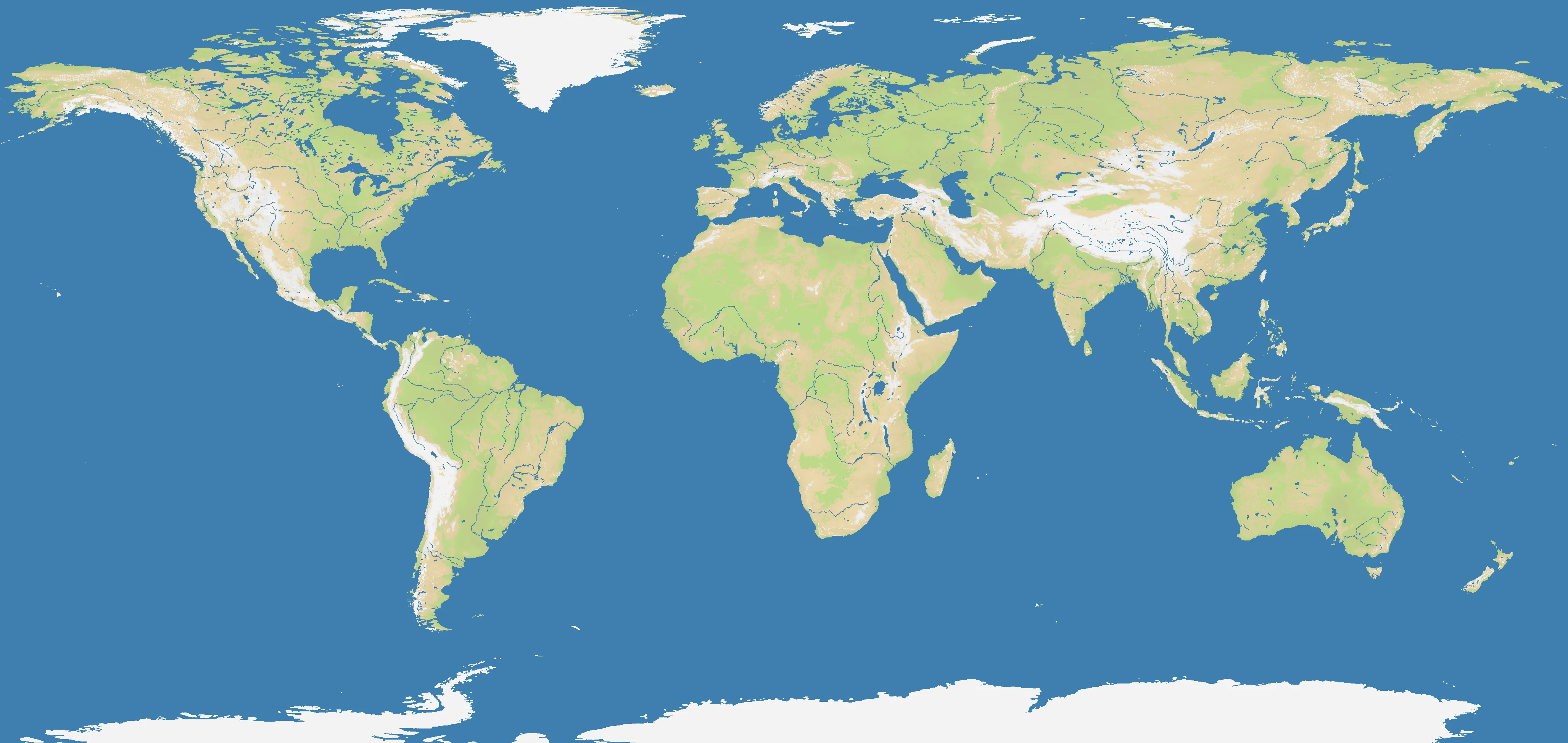
Giant World Map is exactly what the name promises: a full planetary theater stretching from the Americas across the Atlantic and Eurasia to the Pacific, then back again through the world’s largest ocean. Every familiar macro-region appears here — North and South America, Europe, Africa, Asia, Oceania, the Arctic margins, and the immense blue spaces between them. The map’s scale makes even obvious features, like the Mediterranean or Caribbean, feel small compared with the global whole.
At 4108×1948, this is the largest map in OpenFront by a huge margin. Its 29% land ratio mirrors the real Earth closely, which means oceans dominate the visual field and impose genuine strategic distance. Unlike a continental map, where water often frames land, here the oceans are the structure: the Atlantic connects, the Pacific separates, and the Indian Ocean bends the world’s southern routes around Africa and Australia.
That scale transforms how geography behaves. Continents are still decisive bases of power, but none are self-sufficient forever. Chokepoints such as Gibraltar, Suez, Malacca, Panama, and the Turkish Straits matter because the globe is too large to control directly. Giant World Map is less about local terrain tricks and more about mastering the relationship between continental mass, maritime reach, and time.
The History
1492 — The Columbian Exchange Begins
Columbus’s Atlantic voyage permanently connected the Old World and New World in a single global system. Trade, disease, migration, conquest, and empire began moving on a planetary scale — the exact historical logic this map captures.
1869 — The Suez Canal Opens
The opening of Suez radically shortened routes between Europe and Asia, turning one narrow corridor into a global strategic hinge. On a map this large, canal-style chokepoints are priceless because they compress oceans into manageable pathways.
1914 — World War Becomes Truly Global
The First World War began in Europe but quickly pulled in colonies, sea lanes, and distant theaters around the world. It proved that industrial power, maritime logistics, and alliance systems had made global warfare possible even before the air age matured.
1945 — The Planetary Balance of Power
By the end of World War II, the map of global power had become unmistakably worldwide: American naval reach, Soviet continental depth, decolonization, and later Cold War alignments all operated across the entire globe. Strategy could no longer be regional alone.
The Battlefield
Terrain Overview
Giant World Map is a macro-strategy theater defined by scale, distance, and logistics. The 29% land ratio means oceans are everywhere, but unlike smaller naval maps, the seas are so large that controlling them requires staging areas, alliances, and patience. Continental strongholds matter, yet true dominance comes from linking them through chokepoints and ocean routes.
Best Spawns
- Central Eurasia edges — enormous land expansion potential with access toward Europe, the Middle East, or East Asia
- North Atlantic / Mediterranean gateways — premium access to multiple continents and global shipping lanes
- Southeast Asia / Indian Ocean hinge — a superb bridge between the Pacific and western Eurasia
Avoid
- Far isolated Pacific positions — safe initially, but painfully slow to influence the world’s core conflicts
- Deep interior dead ends — strong land buildup, weak ability to project across oceans when the global war accelerates
Strategic Insights
The biggest mistake on Giant World Map is playing it like a normal map. Early local gains matter, but global timing matters more: when to open a second ocean front, when to seize a canal or strait, when to form coalitions, and when to abandon peripheral holdings to protect the core. With 97 nations — more than any other map — this is OpenFront at its most political, most logistical, and most epic.
Fun Facts
- Giant World Map is the largest map in OpenFront at 4108×1948 and the only one in this batch with 97 nations
- Its 29% land ratio almost perfectly matches real Earth’s land-water balance and exactly matches Falkland Islands in percentage despite utterly different scale
- More than any regional map, Giant World Map turns famous chokepoints into strategic superweapons because the alternative routes are so long