Britannia
An island built on invasion and reinvention
Nations 20


The Geography
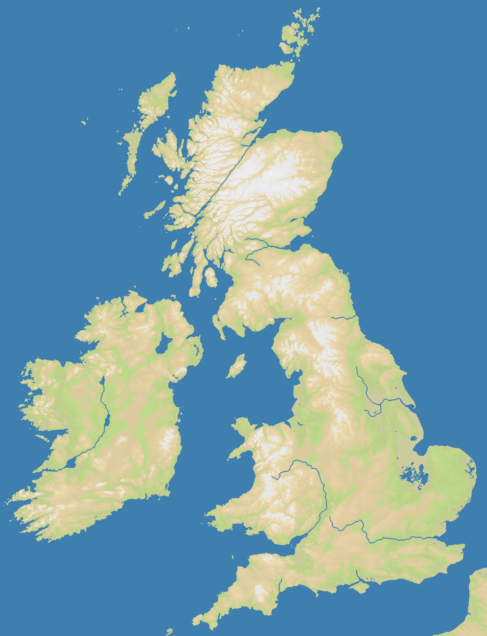
The British Isles are a geographic accident that shaped world history. Britain and Ireland were joined to the European mainland until around 6500 BCE, when rising post-glacial seas broke the land connection and created the Channel — a narrow strip of water that has defined British strategic thinking ever since. The OpenFront Britannia map (1600×2088) captures the full archipelago: mainland Britain with its Highland-Lowland divide, Ireland to the west, the Orkney and Shetland islands to the north, and the Channel coast visible to the south.
At 35.6% land, water dominates — 64.4% of the map is ocean, emphasizing the island geography that makes this map distinct. Scotland’s Highlands create mountain terrain across the northern third. The English Midlands and East Anglia offer flat, agricultural terrain. Wales provides a western mountain barrier. The Thames estuary and London basin anchor the southeast corner.
The History
43 CE — The Roman Invasion
Emperor Claudius sent four legions across the Channel and conquered most of what is now England and Wales within decades. Roman Britain lasted nearly four centuries, leaving roads, fortifications, and the foundation of urban settlement at Londinium (London). Hadrian’s Wall — built across the northern English frontier — is one of history’s most famous territorial markers.
1066 — The Norman Conquest
William of Normandy crossed the Channel, defeated Harold at Hastings, and transformed England overnight. French-speaking Normans replaced the Anglo-Saxon ruling class, English absorbed thousands of French words, and the kingdom became entangled with continental European politics for centuries.
1588 — The Spanish Armada
Philip II of Spain launched 130 ships against England and was defeated — partly by storms, partly by English tactics in the Channel. The failure confirmed English naval dominance in its home waters and launched three centuries of maritime empire-building.
1707 — Acts of Union
England, Wales, and Scotland formally united as Great Britain. Ireland joined in 1801. The United Kingdom at its height controlled the most extensive empire in history — a global network that started from this small, rainy archipelago.
The Battlefield
Terrain Overview
The Highland Line — the geological boundary separating the Scottish Highlands from the Lowlands — is the single most important terrain feature on this map. It creates a near-impassable barrier across the northern third. Southern England’s flat terrain allows rapid east-west movement, while Wales and the Welsh Marches provide a natural western anchor point.
Best Spawns
- Southern England (Thames region) — the historical and geographic core of the island; access to the Channel, flat expansion terrain, central position
- Scotland / Highland fringe — defensible mountain position; you won’t expand fast, but you won’t be easy to dislodge either
- Ireland — separated by sea, natural moat protection, expand across the island before engaging the mainland
Avoid
- Northern Scotland (islands) — isolated, slow expansion, easily cut off by Highland barrier
- Far north coastal positions — minimal neighbors, naval reach required for any significant expansion
Strategic Insights
The Channel coast is strategically vital — whoever controls it can threaten or protect cross-Channel movement and naval trade. Ireland is effectively a separate sub-theatre: if you spawn there, you have time to consolidate the island before committing to the mainland fight. Naval power matters on this map more than most regional maps due to the 64.4% water coverage.
Fun Facts
- Britannia’s 1600×2088 aspect ratio is taller than it is wide — one of the few portrait-orientation maps in the game
- The map includes both Britannia Classic (a variant) and the standard version, each with different dimensions and nation counts
- At playlist frequency 5, Britannia appears regularly — one of the more common regional maps