Bosphorus Straits
Empire rises where continents nearly touch
Nations 12


The Geography
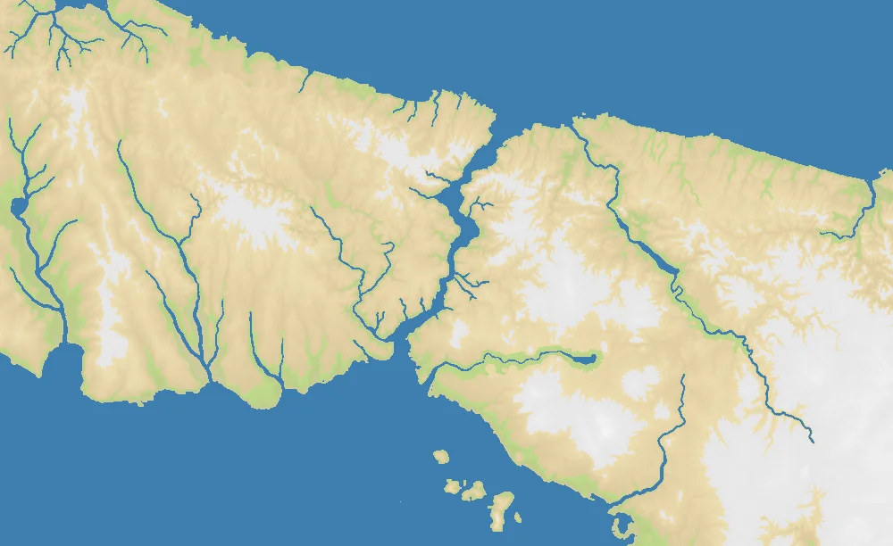
The Bosphorus is one of the narrowest and most consequential waterways on Earth. This twisting strait links the Black Sea to the Sea of Marmara, which in turn opens through the Dardanelles into the Aegean and Mediterranean. On the ground, it is not a broad ocean channel but a constricted maritime corridor with steep shores, headlands, and urbanized banks — a place where Europe and Asia face each other across a few hundred meters of water.
On the OpenFront map, that geography becomes brutally compressed. At just 1000×612 pixels, Bosphorus Straits is the smallest real-geography map in the game, yet it still packs in 12 nations and a hefty 63% land ratio. That makes it feel less like a sprawling naval theater and more like a knife fight around a river mouth: short travel times, constant border pressure, and almost no dead space.
The surrounding terrain matters as much as the channel itself. To the north lies the opening toward the Black Sea; to the south, the approach to the Sea of Marmara and historic Constantinople. Every shoreline is meaningful, every crossing point is contested, and even small peninsulas become natural fortresses because there is so little room to retreat.
The History
660 BCE — Byzantion Founded
Greek settlers established Byzantion on the European side of the strait, recognizing immediately what the map makes obvious: whoever sits here can watch ships move between two seas. The site prospered because geography did most of the strategic thinking for it.
330 CE — Constantinople Becomes Imperial Capital
When Constantine refounded the city as Constantinople, Rome’s eastern empire gained a capital built directly on the chokepoint. From here, emperors could dominate trade, taxation, and naval movement between the Black Sea world and the Mediterranean basin.
1453 — The Ottoman Conquest
Mehmed II’s capture of Constantinople ended the Byzantine Empire and turned the Bosphorus into the heart of Ottoman power. Ottoman control of both shores transformed the strait from a frontier into an imperial hinge connecting Balkan and Anatolian territories.
1936 — The Montreux Convention
The modern Turkish Republic secured international recognition of its authority over the Turkish Straits through the Montreux Convention. Even today, the Bosphorus remains a live geopolitical chokepoint, especially for Black Sea naval access.
The Battlefield
Terrain Overview
Bosphorus Straits is defined by one thing: an ultra-tight land-and-water choke where shoreline control matters more than raw space. The high land percentage means there is little safe offshore maneuvering. Instead, fleets support land pushes, crossings, and blockades around a handful of decisive coastal approaches.
Best Spawns
- Southern Bosphorus / Marmara approaches — strongest control over the map’s central crossing zone and access to both shores
- Northern strait entrance — room to pressure traffic toward the Black Sea while still contesting the center quickly
- Compact peninsula positions — easier to defend, with water shielding at least one flank
Avoid
- Dead-center shoreline starts — immediate multi-front pressure with almost no buffer time
- Exposed inland pockets — high land density means neighbors can converge before you establish naval leverage
Strategic Insights
This map rewards tempo more than patience. Because the theater is so small, early hesitation is usually fatal: the first player to secure a strait crossing and lock down adjacent coastlines can split the map in half. Bosphorus Straits plays like a regional chokepoint distilled to its essence — closer to Gibraltar than to a normal continental map, but even more claustrophobic.
Fun Facts
- At 1000×612, Bosphorus Straits is the smallest real-geography map in OpenFront
- Its 63% land ratio makes it dramatically more land-dense than East Asia (34%) or the Falkland Islands (29%) despite being centered on a famous waterway
- With 12 nations in such a tiny footprint, it has one of the most crowded starts-per-pixel ratios of any atlas map